
#UrbanGreenprints for 26 Indonesian cities

The level of detail we typically achieve when classifying land use in urban green spaces. Here, in a park in Jakarta, we analysed the percentage of ‘bare ground’ (displayed in gray), a useful metric to understand where greening efforts should take place. Although this example is specific to Indonesia, we believe it holds great potential for other cities dealing with similar land use problems.
PROOF OF CONCEPT
Green City Watch’s method of mapping the quality of urban green space was showcased at a World Bank-hosted event in June 2018, where we met the World Bank’s Geospatial Operations Support Team (GOST), which helps operational teams apply geospatial technology to development problems. Facilitated by GOST, we were honored to collaborate with the World Bank’s City Planning Labs (CPL) team, whose mandate is to enhance evidence-driven urban planning in Indonesia.
To establish a proof of concept, we analyzed 26 of Indonesia’s most populated cities, including Jakarta, a ‘megacity’ and the largest city in Southeast Asia, with an estimated population of over 10 million people. Jakarta is set to surpass Tokyo as the world’s largest city with 35.6 million people by 2030.
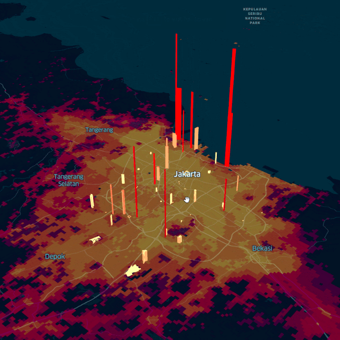
Example visualization built for Indonesian policymakers to display the ‘bare ground’ metric for the pilot study (made with Kepler).
The proof of concept tested the identification of the geographical extent and location of parks within these cities. Within 3 months, we had managed to successfully identify 531 parks within the selected 26 cities, which together represents a total of 1,817 hectares of urban green space in Indonesia. We also managed to capture information regarding the park’s infiltration capacity, availability of amenities and recreational facilities, green versus paved ratio, and the number of trees within the parks, along with other variables by leveraging the publicly available data through the OpenStreetMap (OSM) initiative.
The results have consolidated the importance of comprehensible datasets for green and blue space management and resulted in a year-long follow up assignment (2019-2020) for Indonesian policymakers.
TOOLS & SERVICES:
Green City Watch Index
Holistic impact assessment on sustainability
Identification of intervention hotspots and opportunities
KEY OBJECTIVES:
Urban green space management
Related Media
Maxar: Utilizing Geospatial AI to improve Indonesia’s urban green spaces
SatMagazine: Green City Watch monitors urban green space — from space